(5,539 m, 240+, 135-)
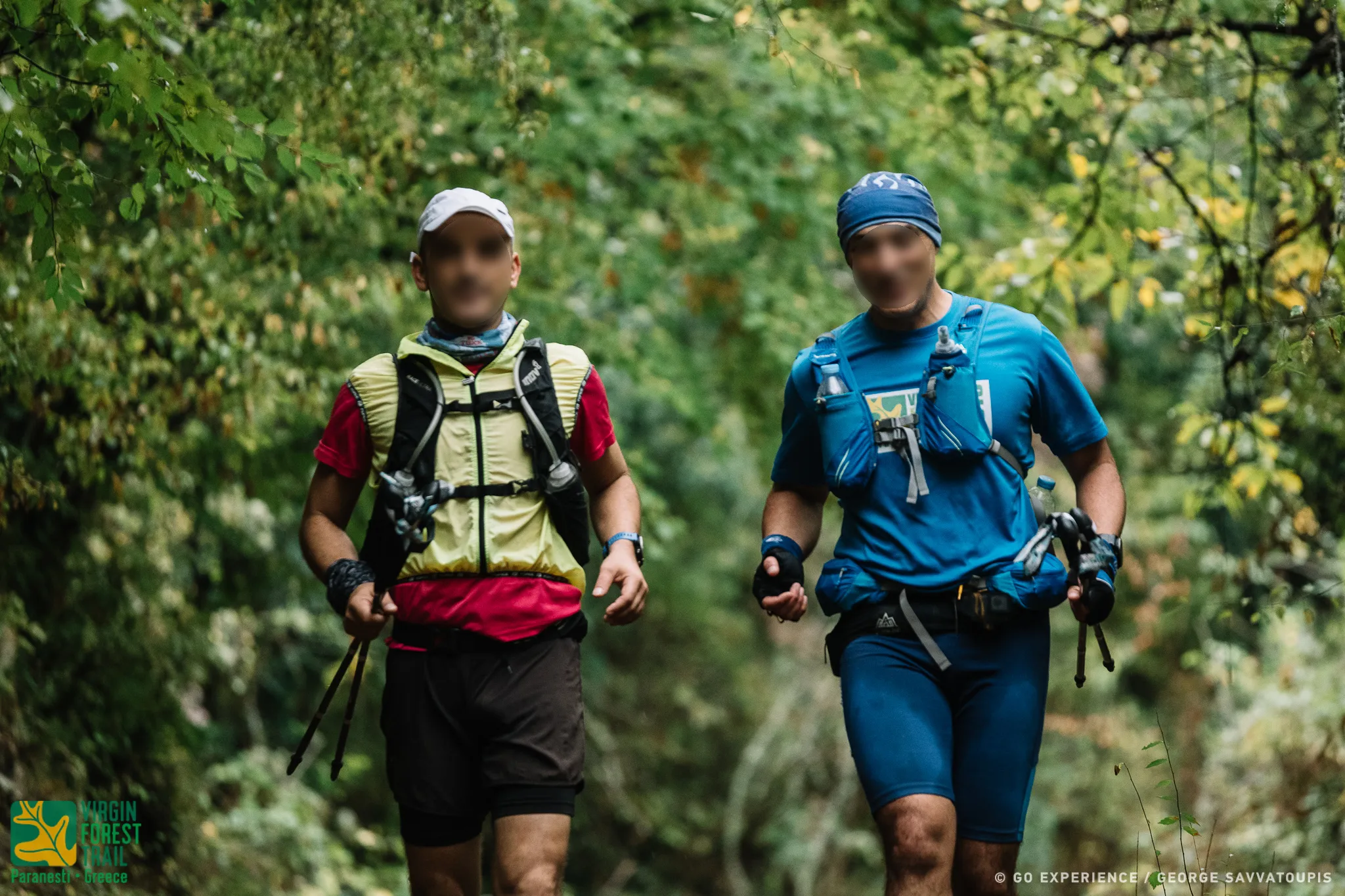
Start from the square of the Paranesti railway station. The beginning of the race route is the same as that of the VFUT and Paranestio Monopati (R.P) races. The first 700 asphalt meters pass through Paranesti, follow the public road to Silli - Prasinada and reach the Nessos hotel. It follows the dirt road that climbs smoothly and after 1900 m turns left, following an old forest uphill road for 825 m that leads to a hill where a relay antenna is located. To the right of the edge of the ridge, the village of Tholos with its picturesque two-story half-demolished houses. Turning left, the route enters a downhill path that follows the edge of the ridge for 1431 m until it descends steeply and meets the Silli-Prasinada public road. It crosses the asphalt vertically, crosses the opposite side of the road and after 20 m turns left going down a few meters below to meet the Arkudorema and the riverside path of the return of the race.
Turn right and in a few meters (312 m) following the riverside path and in the opposite direction to the flow of the Arkudorematos, we arrive at the facilities of the old Porcel construction site, an old remnant of mining activity in the area, where the first Control and Timing Point of the match.
(7,369 m, 625+, 330-)
From the Porcel Control Point the route passes for 205 m through the deserted facilities of the construction site and exits on the public road to Prasinada.
It turns left following the public road for 358 m. To the right of the public road there is a forest road. At the junction of the forest and public road, the route turns right and follows the uphill path for 1633 m.. The route climbs steeply at the beginning and reaching the top of the ridge enters a beautiful oak and beech forest. It then descends to meet the bed of the Cold Stream through a very nice route.
It crosses the stream, turns left and climbs for 228 m. At this point it will meet the well-maintained old path that climbs smoothly to Vunoplagia. Turn right and follow the path. It will pass through the ruins of an old military barracks and climb neck-high through beech and oak forest.
The descent begins. It follows the downhill path for 450 m and meets the dirt road that descends towards Vounoplaya. It turns left and follows the downhill dirt road for 840 m. At 840 m on the left turn of the dirt road, the race route will turn right onto the path that descends towards the deserted village of Vounoplagia for 440 m. He arrives at the renovated village church where the first Supply Station is located.
(6186m, 465m+, 215-)
From the renovated church of Vounoplagia. The route follows for 1220m the old path that descends to the bed of Arkudoremos. Upon reaching the bed, it turns left and in about 200 meters it meets the Arkudorema. From this point begins the uphill to Silli. The route passes Arkudorema, turns right and again meets the asphalt road to Silli and Prasinada. It follows him for 430m. turning left on a concrete road that leads to Hatziantoni farm.
It passes through the farm, enters a path and in 400m, meets a stream. He passes it by turning right and going uphill through beech and hazel forest, always following the old Weaio path, he reaches the village of Silli, where the second Supply Station is.
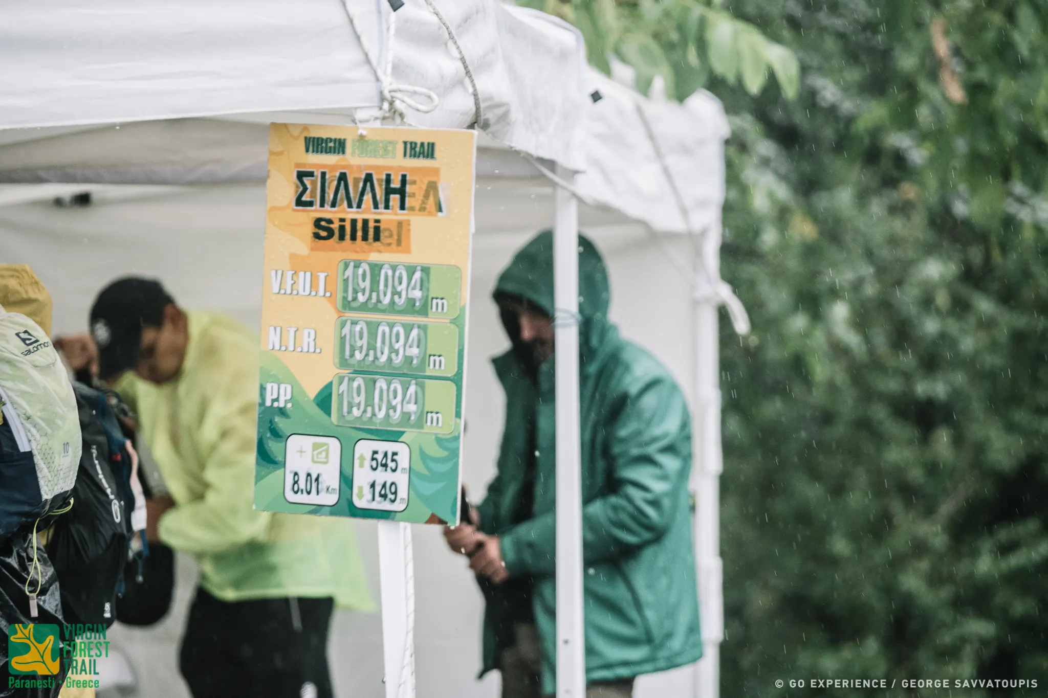
(8.010 m, 5454, 149-)
From the Filling Station of Silli, the route follows the concrete road for 126 m and at the watering hole it meets, it turns right and enters an uphill path. On the hill at 871 m it meets the ruins of an old settlement, which it crosses. Descending at 1670 m near a watering point, it meets an old military road. Checkpoint. It turns left and follows it gently uphill through a picturesque beech forest for 1646 m. At this point you will meet another forest road coming from Prasinada. Checkpoint.
The route turns left and follows the level forest road for 477 m to the farm where the dirt road stops. The route now turns right before the farm and generally downhill, with only a few minor ups and downs, follows an old logging path.
At the end of the downhill path, it crosses a small stream and meets the dirt road that leads to Oxia. Checkpoint. ATTENTION Turn right following the forest road that goes uphill for a while. The route leads to a clearing and re-enters a wonderful beech forest. Turning right, it crosses a small bridge, now boarded up, and ascends briefly to meet another forest road. At the dirt road intersection, turn left. At all junctions and intersections there are direction indicators, Checkpoints and organization signals. At 776 m it meets Kormoplatia (plateau) and turns left.
It descends and meets a small river that comes from higher up. It crosses it diagonally and follows the old logging road through a magnificent beech forest for another 2,162 m from the stream. There the logging road ends and the scenic path begins that gently takes us up to the old military outpost of Pagalos at 673 m.
There and the third Supply Station.
(8,537 m, 30+, 865-)
From the military outpost of Pagalou, which is located in a wonderful place in the midst of lush beech vegetation, the route turns left, leaving the dirt road. From here begins the long descent to Zarkadia. It turns left and in 430 m the forest road ends leading to a water source. From there begins the very downhill path that meanders constantly to reach 3,038 on the Zarkadia - Pefki dirt road. The route follows the path for 386 m, parallel to the dirt road and at 3,420 m it comes out on the Zarkadia - Pefki dirt road. It follows the downhill dirt road to Zarkadia for 3,050 m. ATTENTION follow the route on the edge of the dirt road. At 6,470 m it meets the old entrance to Oxia.
Checkpoint. It turns left, descends for a while, passes over a stone bridge and follows a scenic uphill path to the right at the beginning and downhill at the end.
Down on the right is the dirt road to Zarkadia. Very quickly, the route will approach the small stream and after crossing it will come out at the intersection with the public road that goes to Thermia - Frakto. It follows the downhill public road for 567 m and reaches the fourth Refueling Station, that of Zarkadia, where there is also the first exclusion time limit at 14:00 pm on Saturday.
(6022m, 70m:, 150m -)
From the Zarkadia Fuel Station, the route follows the asphalt for 100 m, crosses the Diavoloremos bridge and immediately turns left, heading southwest, now running on a dirt forest road. In the first 600 m it passes through the farm of Poulukidis. For a few meters he follows the downhill forest road which very quickly becomes a path. It is now located on the right and next to the bank of Diavoloremos.
To the left and above the bed of the stream is the Paranesti - Thermion road, from where spectators can watch the match. The route goes up and down with small slopes, which at the high points create wonderful viewing positions (balconies). You can admire the bed of Diavoloremos with its meanderings but also the lake of Platanovrisi, At 4200 m it passes below the ruins of the abandoned village of Polygephyros and at 6022 m it reaches the lake kiosk at the place of Glossa, a strip of land that enters the lake of Platanovrisi, The Checkpoint is now located at the lake pavilion.
(14,794m, 680m -, 325m -)
Large, isolated but beautiful section of the race course. From the gazebo of the lake of Platanovrysis, the forest path marked "S" starts, which will be found along the entire length of this section of the route. Leaving the lake pavilion, it continues west and next to the lake. The route soon climbs steeply (40 N) passing through a pass with a wonderful panoramic view of the lake and its inhabitants (legons, ducks, cormorants, mergansers), nesting in the dead branches of the trees that protrude from the surface of the lake. Immediately afterwards, it descends again to the level of the lake, turning north and following the course of the Great Stream in the opposite direction. The route moves through a forest of oaks, beeches, hazelnuts and next to the remains of old livestock settlements.
You can admire the many single arched stone bridges, many of which we pass over. You will also definitely see the tracks of the forest dwellers (wild boars) with the characteristic diggings.
CAUTION! At 3,515 m from the STEK of Platanovrisi, the route will meet the intersection of the path that goes right to MOMIA. The race route continues straight downhill.
The route goes up and down with a general uphill slope. It moves along the greater part of the left of the Great Stream And only towards the end it passes over the Great single-arched bridge, leaving the M. Rema on the right. (11,801 m) from the STEK of Platanovrisi. It is the part of the route with the many streams. You will pass the Chernaki stream which you will have on your left and the Stravorema. Dense beech vegetation and sweet uphills, the path will emerge in a clearing that joins the old forest road, which it follows to reach the fifth Alikioi Refueling Station a few meters away.
(4.219 µ, 570 µ+, 60 µ-)
Leaving the Alikioi Supply Station (Mandria), the route turns right going down the path to the bed of the stream of Alikioi (Mandria).
It passes over the small single-arched bridge and begins the long arduous climb up to the Andero site. The mosaic of vegetation is mainly created by oaks and beeches. As the altitude increases, reaching Andero and after passing by the remains of a settlement, the first conifers begin to appear.
The path ends on a dirt forest road where the long climb ends. There is the Central Supply Station, Andros, with the second cut-off time at 20:00 on Saturday. At this point, the mandatory equipment check will also take place.
(20,145 m, 440 m+, 765 m-)
CAUTION! Leaving the Anderos Supply Station, stock up on plenty of water, because the route in this part of the race is the longest and does not encounter a spring or running water because it moves high and panoramic. In this section, the route moves generally to the right and left of the ridge (Anterorachi), with the ravine of Thermia on the left and the ravine of Megalo Remos on the right. It is generally downhill, with several ups and downs for 12,600 meters and passes from panoramic view points. It moves in beech, anvil and hazel forest. After a wonderful panoramic ride you will end up at the MOMA location where the Refueling Station is also located.
From MOMA the route turns left and follows a downhill dirt road and at 170 m in a typical pine tree it turns right, entering a picturesque downhill path with a wonderful view of Lake Platanovrisi. At 1,500 m the route meets the intersection that leads to Megalo Rema on the right. Turn left going downhill towards the ruins of the village of Polygephyro. At 2,500 m, passing by the ruins of the Polygefyrou primary school, it meets the path that comes from the zarkadia and goes to the STEK of Platanovrisi lake, which the athletes had followed a few hours before. Turn left And for 4,550 m follow the path to Zarkadia in the opposite direction that the athletes had followed in the morning. Towards the end of the route, the dirt road passes through the Poulukidis compound and exits in a few meters on the Thermia - Paranesti public road. It turns right, goes over the bridge and in 100 m reaches the Zarkadia Fuel Station again with the third cut-off time of 24:00 on Saturday.
(6.767m, 800m+, 20m-)
From the Zarkadia Refueling Station begins the last long, grueling climb up to the neck of Oksia. CAUTION! Stock up on water because there is a big uphill climb and the Silli Supply Station is slow. Having traveled 507m, leave the asphalt and turn left onto the dirt road to Pefki. CAUTION! It does not follow the uphill dirt road to Pefki. Immediately after entering the dirt road, the route turns right onto the same path from which it came before when descending from the Pefki dirt road. It crosses the small river and climbs the slope to descend again next to the stone bridge from where it entered during the descent from Pefki, following a reverse course. From the stone bridge it continues straight, on the beautiful path next to the river. Then, after crossing two small streams, it turns right and steadily follows the path that begins to climb with increasingly steep inclines. In the next 735 meters, it climbs 200 meters of positive altitude difference (altitude 665 meters) to find itself at the first peak of the area. Panoramic view, to enjoy the surrounding area. The route turns right and follows the well-maintained path. After 370 meters it reaches the first neck at an altitude of 705 meters. But 632 meters and it reaches the second neck at an altitude of 795 meters. Hang on, the biggest uphill is now over.
Breathing and turning left, it travels the next 660 meters on a smaller slope, crosses a stream and we reach the first ruins of the old settlement of Oxia (altitude 825 meters). Another 100 meters and you come across one of the old taps of the settlement. It will pass by the old aqueduct of the settlement at an altitude of 865 meters and follows the path that meanders through a beech forest after 780mm you will find yourself in the neck of the Beech at an altitude of 955m.
(4433 m, 50m+, 215m-)
From the neck of Beech, the route descends through a beech forest. The route now becomes even more beautiful, as it passes through beautiful clearings and meadows and ends, after about 600 meters, in the bed of a small stream (altitude 910 meters). It crosses the small stream vertically and turns right. Small uphill with an altitude difference of 25 meters and meets the runoff and the remains of an old tap, one of the many traces of human presence in the relatively recent past.
It turns right and comes out again in a clearing. It continues straight through a beech forest that alternates with wild apple, cherry trees, and after 2,000 meters it reaches the pastures (parcharia) of Silli (895 meters altitude). On the right, the characteristic "nose" (cut) of Silli that can be seen from a long distance. A few meters further down it meets a characteristic monument, the point from where the well-maintained downhill path to the village of Silli, 1,445 meters long, begins. In a short while it reaches the newly built church of Silli, where the Silli Refueling Station is located at an altitude of 765 meters.
At this point there is the fourth exclusion time limit at 04:00 on Sunday morning.
(9,751 m, 80+, 585m-)
From the Sili Refueling Station, the race route follows exactly the same route as the climb in Sili from Vounoplagia to the Arkudorematos footbridge, sometimes downhill, returning to Paranesti.
As soon as he crosses the pedestrian bridge of Arkudorematos, he turns right and follows the old picturesque path and the old route of the organization, until the exit of the path at the military bridge of Arkudorematos, on the asphalt of the public road Paranesti - Parasinada. It continues straight, follows the public road to Paranesti, passes in front of the abandoned military outpost and at 485 m turns right to follow a dirt road downhill for a few meters and then to enter the riverside path of Arkudorematos with a special aesthetic. It follows the riverside path with a little care in some passages and in 1367 m it reaches the Porcel Checkpoint.
(7,923 m, 80+, 120-)
From the Porcel Checkpoint, the route continues along the rivers and at 1430 m it comes out on a downhill dirt road that leads to the village of Xagnados, which it follows for about 2 kilometers. At this point it rejoins the path, leaving Xagnanto on the left. The route goes next to the river Nestos for 2203 m and is magnificent.
At this point the route turns left, leaves Nestos behind and climbs for 64 m (last uphill), passes a viewing kiosk and exits on the public road Xagnantos - Paranestiou. Turn right, follow the public downhill road to Paranesti and in 1330 m it ends at the same point where it started, in the square of the Paranesti Railway Station. There you will finish, full of satisfaction and joy for achieving your goal and the end of your adventure.